
Severe thunderstorms rumble to life Tuesday as a large portion of the US is strapped into a temperature roller coaster with notable rises and falls through the weekend.
These kinds of storms – which can generate tornadoes, large hail and damaging winds – are possible at any point in the year if the atmospheric conditions are right. But they typically become more frequent starting in the spring – May to July in the same parts of the Midwest and Great Lakes at risk Tuesday – as warmer temperatures take hold.
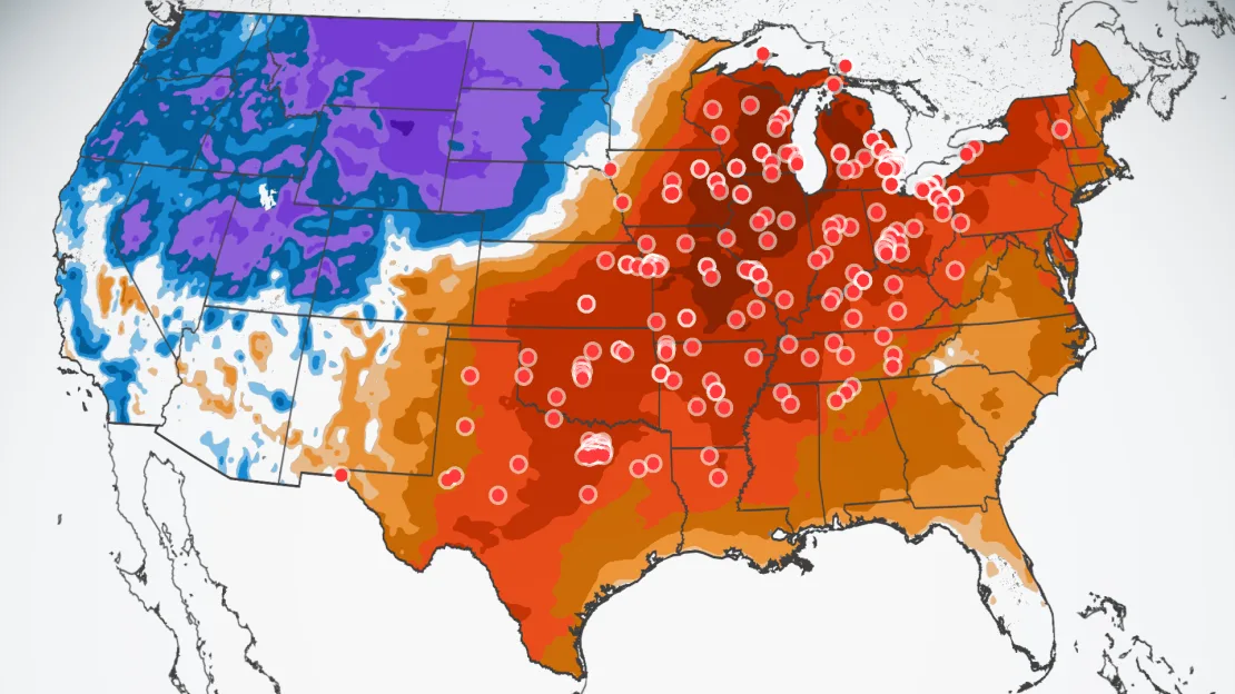
Hundreds of daily temperature records, and even some all-time monthly records, are in jeopardy Monday through Wednesday over the eastern two-thirds of the US.
Humidity will surge in the Midwest and Great Lakes in tandem with the springlike warmth as moist air pumps into the area from the Gulf of Mexico.
The warm, moist air is two of the three ingredients needed to create thunderstorms. A potent cold front associated with a storm tracking into the Midwest will serve as the third ingredient and ignite the severe thunderstorms on Tuesday.
A Level 2 of 4 risk of severe storms is in place for parts of Missouri, Illinois, Wisconsin, Indiana, Michigan and Ohio. Chicago, St. Louis and Indianapolis could all face damaging thunderstorms.
Disruptive thunderstorms look to hold off until the evening across southwestern Michigan, allowing many voters to stay dry at the polls for the Presidential primary Tuesday.
Chicago’s greatest risk for strong thunderstorms spans late Tuesday afternoon and evening, while St. Louis is under a similar threat from the evening into early Wednesday morning.
Damaging wind gusts and large hail are the main risks associated with any severe storms, but a few tornadoes cannot be ruled out.
The risk for severe thunderstorms will decrease by Wednesday as the storm spreads into the East. Rain with a few embedded thunderstorms could soak much of the East Wednesday while temperatures plummet over the central US in the cold front’s wake.
Topsy-turvy temperatures
High temperatures on Monday will soar to 30 degrees above normal across much of the central US. It will feel more like May for Minneapolis while Dallas swelters under 90-plus degree heat more typical of mid-June.
Unseasonable heat spreads east on Tuesday. High temperatures climb 20 to 30 degrees above average from the southern Plains through the Great Lakes. All-time record warm February highs could be in jeopardy, especially in the Midwest and Great Lakes.
High temperatures come crashing right back down for much of the region Wednesday.
Temperatures could drop 30 to 40 degrees in just 24 hours in the central US.
The cold will arrive so abruptly that Tuesday’s stormy weather may end as a bit of wintry mix or snow early Wednesday morning in Chicago.
Chicago is forecast to reach the upper 60s on Monday and the 70s on Tuesday before plummeting to a high in the low 30s Wednesday.
Low temperatures in Minneapolis are forecast to plunge into the single digits by early Wednesday morning.
Wednesday will likely be the warmest day of the week for the East Coast, before the potent cold front arrives and topples temperatures Thursday.
And the weather whiplash won’t stop. The blast of chill will be short-lived as temperatures in the central US climb close to springlike levels again by Friday and much of the East by Saturday.
Above-average warmth is likely to persist through early March over the eastern half of the US, according to the Climate Prediction Center.
Winter has become the fastest-warming season for nearly 75% of the US as global temperatures rise because of human-caused climate change.